← survey home · UK climbs · US climbs · Swiss climbs · Austrian climbs · French climbs
French Hill Climbs — road gradients measured by LiDAR
Road climbs across the Alps, the Vosges, the Pyrenees, the Massif Central, the Jura, Corsica, Provence, the north-west, the north-east and the Centre (70 departments), measured on IGN’s LiDAR HD 0.5 m laser surveys and ranked by the steepest 25 m — part of the HowSteep survey. What the survey is, and how to read a gradient ladder →
Surveyed here: the great cols and the village ramps alongside the steep lanes only the locals knew, found by the same systematic search that produced the UK catalogue.
France so far is the Alps, the Vosges, the Pyrenees, the Massif Central, the Jura, Corsica, Provence, the north-west, the north-east and the Centre — the departments between the Rhône and the Italian border, from Lake Geneva to the Mediterranean; the Vosges massif from the Ballon d’Alsace to the Donon; the six Pyrenean departments from the Atlantic at Hendaye to the Mediterranean at Banyuls; the volcanic uplands and gorges of central France; the limestone plateau and passes along the Swiss border; the island’s high cols and coast roads; the hills and coast east of the Rhône; the Suisse normande, the Perche and the Alpes mancelles, from the Channel to the Loire; the Ardennes, the Argonne and the côtes de Meuse, the Montagne de Reims and the Boulonnais; and the Loire valley from Tours to Sancerre, the Berry and the western edge of Paris. The rest of the country follows region by region as IGN’s LiDAR HD survey completes its national coverage; Brittany, the Bassin Parisien, the Morvan and the Nord wait for IGN to publish their ground model. One well-known Vosges climb, the Col du Petit Ballon, is not here yet: the roads at the pass carry no name or number in OpenStreetMap, so no route could be built for it.
Every climb here carries a surface and access chip from BD TOPO®, IGN’s national topographic database, cross-checked with OSM; a road the database marks as restricted (seasonal closure, forest road, permit, toll) ranks with that restriction stated. Where a check is still pending, the page says so.
6246 climbs published · 932.6 km of total ascent (a rough total — it adds every small rise in the unsmoothed 1 m profile, noise included) · Ain, Allier, Alpes-Maritimes, Alpes-de-Haute-Provence, Ardennes, Ardèche, Ariège, Aube, Aude, Aveyron, Bas-Rhin, Bouches-du-Rhône, Calvados, Cantal, Cher, Corrèze, Corse-du-Sud, Creuse, Doubs, Drôme, Eure, Gard, Gers, Haut-Rhin, Haute-Corse, Haute-Garonne, Haute-Loire, Haute-Marne, Haute-Savoie, Haute-Vienne, Hautes-Alpes, Hautes-Pyrénées, Hauts-de-Seine, Hérault, Indre, Indre-et-Loire, Isère, Jura, Landes, Loir-et-Cher, Loire, Loire-Atlantique, Lot, Lozère, Maine-et-Loire, Marne, Mayenne, Meurthe-et-Moselle, Meuse, Moselle, Métropole de Lyon, Orne, Pas-de-Calais, Puy-de-Dôme, Pyrénées-Atlantiques, Pyrénées-Orientales, Rhône, Sarthe, Savoie, Seine-Maritime, Somme, Tarn, Tarn-et-Garonne, Val-d'Oise, Val-de-Marne, Var, Vaucluse, Vendée, Vosges and Yvelines · share
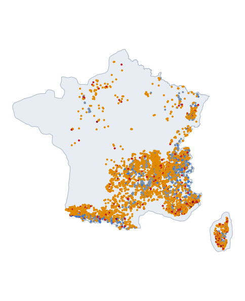 All the measured roads on one map →
Surface: · Caveated rows: (ranks stay the true ranks) · paved is preselected and the toggle drives every ranking table below; gravel, mixed and surface-unverified roads appear under all surfaces. Ranked by one steepest window, a row may be a brief sharp pitch or a sustained traditional climb — the Length and Overall columns tell you which.
On this page: steepest 10 m · 25 m · 50 m · 100 m · largest net rise · provisional (179) · all climbs (6246) · under review (2082) — the rankings are the evidence-quality A/B subset; all climbs is every page, review-status and annex entries included.
Steepest 10 m
| # | Climb | Department | Max | Length | Overall | Surface | Evidence |
|---|---|---|---|---|---|---|---|
| 1 | Chemin de Neyramand | Ardèche | ≈caveated39% | 5594 m | 7.8% | paved | Good |
| 2 | Chemin de la Sirole | Alpes-Maritimes | 38% | 1069 m | 7.9% | paved | Good |
| 3 | Boulevard Guynemer | Bouches-du-Rhône | ≈caveated38% | 671 m | 9.9% | paved | Good |
| 4 | Chemin de l'Épalud | Isère | ≈caveated38% | 1979 m | 3.4% | paved | Good |
| 5 | Route de Montgoutoux | Isère | ≈caveated37% | 5038 m | 7.5% | paved | Good |
| 6 | Chemin de Manine | Hautes-Pyrénées | ≈caveated37% | 1235 m | 8.0% | paved | Good |
| 7 | Chemin de la Robinière | Isère | ≈caveated36% | 1865 m | 7.5% | paved | Good |
| 8 | Montée des Issards | Alpes-Maritimes | 36% | 236 m | 16.7% | paved | High |
| 9 | Route de La Turbie | Alpes-Maritimes | ≈caveated36% | 808 m | 7.1% | paved | Good |
| 10 | Discovered lane (41.5564, 9.0282) | Corse-du-Sud | 35% | 3947 m | 7.1% | paved | High |
| 11 | Chemin de la Tella | Alpes-Maritimes | ≈caveated35% | 626 m | 20.2% | paved | Good |
| 12 | Discovered lane (45.3723, 2.5851) | Cantal | ≈caveated35% | 2654 m | 9.5% | paved | Good |
| 13 | A Costa di Brancuciu | Corse-du-Sud | ≈caveated35% | 979 m | 8.1% | paved | Good |
| 14 | Montée des Alboscs | Haute-Loire | 35% | 210 m | 18.6% | paved | High |
| 15 | Chemin des Rangets | Haute-Savoie | ≈caveated34% | 503 m | 11.2% | paved | Good |
Steepest 25 m
| # | Climb | Department | Max | Length | Overall | Surface | Evidence |
|---|---|---|---|---|---|---|---|
| 1 | Route de La Turbie | Alpes-Maritimes | ≈caveated34.5% | 808 m | 7.1% | paved | Good |
| 2 | Montée des Issards | Alpes-Maritimes | 32.7% | 236 m | 16.7% | paved | High |
| 3 | Chemin Daou Ribas | Alpes-Maritimes | 31.7% | 1320 m | 11.2% | paved | Good |
| 4 | Combe de Notre-Dame | Alpes-Maritimes | ≈caveated31.6% | 475 m | 19.6% | paved | Good |
| 5 | Montée de Subreville | Alpes-Maritimes | 31.5% | 447 m | 12.2% | paved | Good |
| 6 | Route de Montgoutoux | Isère | ≈caveated31.4% | 5038 m | 7.5% | paved | Good |
| 7 | Chemin de Peyre Amoroure | Hautes-Alpes | ≈caveated31.1% | 2735 m | 9.1% | paved | Good |
| 8 | Chemin du Pérussier | Var | 31.0% | 240 m | 18.5% | paved | High |
| 9 | Discovered lane (43.6097, 6.9113) | Alpes-Maritimes | 31.0% | 222 m | 15.0% | paved | Good |
| 10 | Chemin de la Tella | Alpes-Maritimes | ≈caveated31.0% | 626 m | 20.2% | paved | Good |
| 11 | Chemin du Tuf | Alpes-Maritimes | 30.9% | 739 m | 13.5% | paved | Good |
| 12 | Discovered lane (41.5564, 9.0282) | Corse-du-Sud | 30.9% | 3947 m | 7.1% | paved | High |
| 13 | Route du Pré Neuf | Alpes-Maritimes | 30.8% | 939 m | 11.0% | paved | Good |
| 14 | Chemin des Cambreniers | Alpes-Maritimes | ≈caveated30.8% | 1894 m | 8.9% | paved | Good |
| 15 | Chemin de Panisse | Alpes-Maritimes | 30.7% | 334 m | 18.8% | paved | High |
Steepest 50 m
| # | Climb | Department | Max | Length | Overall | Surface | Evidence |
|---|---|---|---|---|---|---|---|
| 1 | Route de La Turbie | Alpes-Maritimes | ≈caveated32.1% | 808 m | 7.1% | paved | Good |
| 2 | Montée des Issards | Alpes-Maritimes | 30.6% | 236 m | 16.7% | paved | High |
| 3 | Discovered lane (41.6688, 8.9090) | Corse-du-Sud | 29.9% | 475 m | 9.8% | paved | High |
| 4 | Chemin du Pérussier | Var | 29.6% | 240 m | 18.5% | paved | High |
| 5 | Chemin du Tuf | Alpes-Maritimes | 29.2% | 739 m | 13.5% | paved | Good |
| 6 | Route du Pré Neuf | Alpes-Maritimes | 29.2% | 939 m | 11.0% | paved | Good |
| 7 | Montée de Subreville | Alpes-Maritimes | 28.9% | 447 m | 12.2% | paved | Good |
| 8 | Chemin de Roumanille | Alpes-Maritimes | ≈caveated28.9% | 378 m | 14.6% | paved | Good |
| 9 | Chemin de Font Luègne | Alpes-Maritimes | 28.8% | 499 m | 11.7% | paved | High |
| 10 | Chemin de Panisse | Alpes-Maritimes | 28.8% | 334 m | 18.8% | paved | High |
| 11 | Chemin des Salles | Alpes-Maritimes | 28.7% | 328 m | 18.4% | paved | Good |
| 12 | Chemin des Camplets | Hautes-Pyrénées | ≈caveated28.5% | 302 m | 22.3% | paved | Good |
| 13 | Chemin des Cambreniers | Alpes-Maritimes | ≈caveated28.4% | 1894 m | 8.9% | paved | Good |
| 14 | Chemin de la Fontaine | Isère | ≈caveated28.3% | 741 m | 14.1% | paved | Good |
| 15 | Chemin de la Tella | Alpes-Maritimes | 28.3% | 626 m | 20.2% | paved | Good |
Steepest 100 m
| # | Climb | Department | Max | Length | Overall | Surface | Evidence |
|---|---|---|---|---|---|---|---|
| 1 | Chemin de Font Luègne | Alpes-Maritimes | 28.3% | 499 m | 11.7% | paved | High |
| 2 | Chemin de la Fontaine | Isère | ≈caveated28.0% | 741 m | 14.1% | paved | Good |
| 3 | Chemin du Gard | Isère | ≈caveated27.9% | 935 m | 11.4% | paved | Good |
| 4 | Chemin de la Tella | Alpes-Maritimes | ≈caveated27.8% | 626 m | 20.2% | paved | Good |
| 5 | Chemin des Camplets | Hautes-Pyrénées | ≈caveated27.4% | 302 m | 22.3% | paved | Good |
| 6 | Chemin du Riou | Alpes-Maritimes | 27.2% | 352 m | 17.0% | paved | High |
| 7 | Discovered lane (41.6688, 8.9090) | Corse-du-Sud | 27.1% | 475 m | 9.8% | paved | High |
| 8 | Chemin du Tuf | Alpes-Maritimes | ≈caveated27.1% | 739 m | 13.5% | paved | Good |
| 9 | Route du Pré Neuf | Alpes-Maritimes | ≈caveated27.0% | 939 m | 11.0% | paved | Good |
| 10 | Montée des Issards | Alpes-Maritimes | 26.8% | 236 m | 16.7% | paved | High |
| 11 | Discovered lane (43.5859, 7.0678) | Alpes-Maritimes | 26.5% | 268 m | 20.3% | paved | Good |
| 12 | Chemin du Pérussier | Var | 26.5% | 240 m | 18.5% | paved | High |
| 13 | Chemin du Goubet | Alpes-Maritimes | ≈caveated26.1% | 319 m | 15.4% | paved | Good |
| 14 | Chemin du Vallon d'Aussel | Alpes-Maritimes | ≈caveated26.0% | 643 m | 8.7% | paved | Good |
| 15 | Hameau de Centraux | Ariège | ≈caveated25.9% | 350 m | 20.3% | paved | Good |
≈ measured under tree canopy or near a structure at that window — the value stands but is less certain — the flag does not say whether the true value is higher or lower. Rankings include evidence quality A and B only; every row carries its surface chip, and restricted-access roads (toll/park) carry a controlled-access note — a real road lists, with its restriction stated.
Largest net rise
| # | Climb | Department | Net rise | Total ascent | Length | Overall | Surface |
|---|---|---|---|---|---|---|---|
| 1 | Col de la Bonette from Saint-Étienne-de-Tinée | Alpes-Maritimes | 1548 m | 1729 m | 24229 m | 6.4% | paved |
| 2 | Col de Restefond from Jausiers | Alpes-de-Haute-Provence | 1452 m | 1497 m | 20634 m | 7.0% | paved |
| 3 | Col de la Cime de la Bonette from Jausiers | Alpes-de-Haute-Provence | 1434 m | 1495 m | 20830 m | 6.9% | paved |
| 4 | Col du Grand Colombier from Culoz | Ain | 1237 m | 1277 m | 17288 m | 7.2% | paved |
| 5 | Puerto de Forqueta from Aragnouet | Hautes-Pyrénées | 1205 m | 1285 m | 7820 m | 15.4% | paved |
| 6 | Crêt de Châtillon from Annecy | Haute-Savoie | 1192 m | 1197 m | 16861 m | 7.1% | paved |
| 7 | Route du Grand Colombier | Ain | 1187 m | 1209 m | 14669 m | 8.1% | paved |
| 8 | Col du Galibier from Valloire | Savoie | 1184 m | 1231 m | 16965 m | 7.0% | paved |
| 9 | Cormet de Roselend from Bourg-Saint-Maurice | Savoie | 1145 m | 1203 m | 19032 m | 6.0% | paved |
| 10 | Route Impériale | Savoie | 1104 m | 1143 m | 11309 m | 9.8% | paved |
| 11 | Col de Sevi from Sagone | Corse-du-Sud | 1098 m | 1134 m | 20365 m | 5.4% | paved |
| 12 | Route des Gentianes | Isère | 1078 m | 1081 m | 12944 m | 8.3% | paved |
| 13 | Port de Balès from Ferrère | Hautes-Pyrénées | 1072 m | 1109 m | 16073 m | 6.7% | paved |
| 14 | Col d'Andrion from La Tour | Alpes-Maritimes | 1047 m | 1187 m | 17015 m | 6.2% | paved |
| 15 | Col de Granon from Saint-Chaffrey | Hautes-Alpes | 1037 m | 1042 m | 11307 m | 9.2% | paved |
Net rise is the endpoint elevation difference; total ascent counts every metre climbed, including dips regained — and, since it adds the small rises of an unsmoothed 1 m profile without ever subtracting, read it as indicative rather than surveyed (why).
Provisional measurements
Measured by exactly the same method, but the evidence quality sits below B — usually short-window maxima steep enough to trigger the plausibility review, awaiting a closer look. The numbers stand as measured; treat them as provisional until reviewed. What the evidence-quality letters mean →
| Climb | Department | Length | Overall | Max 25 m | Surface | Notes |
|---|---|---|---|---|---|---|
| Heleteneko bidea | Pyrénées-Atlantiques | 1.2 km | 10.9% | 25.7%≈caveated | paved | |
| Discovered lane (42.9252, 9.4505) | Haute-Corse | 0.2 km | 14.5% | 25.2% | mixed surface | 59% unpaved |
| Chemin du Sertaix | Isère | 1.0 km | 8.7% | 25.1%≈caveated | paved | |
| Chemin de Cayonnière | Isère | 1.7 km | 11.4% | 24.9%≈caveated | paved | |
| Chemin de Courrèges | Haute-Garonne | 2.4 km | 9.5% | 24.8%≈caveated | mixed surface | 20% unpaved |
| Chemin de la Vigne Blanche | Savoie | 0.2 km | 15.4% | 24.7%≈caveated | paved | |
| Rue des Hauts d'Alzone | Corse-du-Sud | 0.3 km | 13.7% | 24.6% | paved | |
| Chemin Raton | Bouches-du-Rhône | 0.2 km | 17.1% | 24.5%≈caveated | paved | |
| Chemin de Colombaille | Var | 1.2 km | 11.8% | 24.4%≈caveated | mixed surface | 23% unpaved |
| Discovered lane (45.4506, 4.3399) | Loire | 0.5 km | 11.6% | 24.3%≈caveated | mixed surface | 32% unpaved |
| Rue de Saint-Jean | Haute-Garonne | 0.3 km | 14.5% | 24.1%≈caveated | paved | |
| Chemin du Col de Farran | Hérault | 0.6 km | 7.4% | 24.0% | paved | |
| Chemin de Ronesque | Aveyron | 2.5 km | 11.0% | 23.8%≈caveated | paved | |
| Chemin des Turcs | Hautes-Alpes | 2.8 km | 9.7% | 23.7%≈caveated | mixed surface | 46% unpaved |
| Chemin de la Martinie | Aveyron | 5.0 km | 8.4% | 23.7%≈caveated | paved | |
| Chemin de l'Homnesy | Isère | 2.5 km | 9.9% | 23.7%≈caveated | paved | |
| Côte de Jordy | Lot | 1.0 km | 11.7% | 23.7%≈caveated | paved | |
| Chemin des Chevreuils | Corrèze | 0.2 km | 21.9% | 23.2%≈caveated | paved | |
| Discovered lane (44.5120, 3.3411) | Lozère | 1.5 km | 10.3% | 23.2%≈caveated | paved | |
| Chemin des Robarus | Drôme | 0.8 km | 9.7% | 23.2%≈caveated | paved | |
| Discovered lane (43.1584, -1.3423) | Pyrénées-Atlantiques | 5.7 km | 9.8% | 23.1%≈caveated | paved | |
| Chemin de la Fond Satin | Rhône | 2.1 km | 6.0% | 23.1%≈caveated | paved | |
| Route de Taloire | Alpes-de-Haute-Provence | 2.0 km | 11.2% | 23.0%≈caveated | paved | |
| Discovered lane (43.1309, -1.1582) | Pyrénées-Atlantiques | 1.3 km | 13.0% | 23.0%≈caveated | mixed surface | 33% unpaved |
| Route de Laumond | Lot | 0.5 km | 11.6% | 23.0% | paved | |
| Chemin du Barnier | Alpes-Maritimes | 0.8 km | 8.3% | 22.8%≈caveated | paved | |
| Discovered lane (45.6493, 6.4688) | Savoie | 15.0 km | 8.1% | 22.8%≈caveated | paved | |
| Rue Claude d'Elvincourt | Gard | 0.4 km | 9.7% | 22.7% | paved | |
| Rue de la Chapelle | Loir-et-Cher | 0.2 km | 18.0% | 22.6%≈caveated | paved | |
| Discovered lane (43.6051, 6.3877) | Var | 0.5 km | 11.6% | 22.5%≈caveated | paved | |
| Chemin du Bourrut | Ariège | 0.9 km | 9.5% | 22.5%≈caveated | paved | |
| Route du Col de Lafatigue | Pyrénées-Atlantiques | 2.2 km | 12.2% | 22.5%≈caveated | paved | |
| Rue Saint-Jean | Hautes-Pyrénées | 1.3 km | 11.5% | 22.4%≈caveated | paved | |
| Oihanarteko bidea | Pyrénées-Atlantiques | 0.2 km | 9.9% | 22.3%≈caveated | paved | |
| Discovered lane (45.3238, 2.7411) | Cantal | 4.0 km | 8.5% | 22.2% | paved | |
| Discovered lane (45.3291, 2.7338) | Cantal | 3.6 km | 8.8% | 22.2% | paved | |
| Discovered lane (45.3309, 2.5036) | Cantal | 1.5 km | 8.4% | 22.2%≈caveated | paved | |
| Discovered lane (44.5307, 3.3809) | Lozère | 2.7 km | 10.1% | 22.1%≈caveated | paved | |
| Route de Giraud | Ardèche | 1.9 km | 7.9% | 22.1%≈caveated | paved | |
| Chemin des Biesses | Rhône | 1.4 km | 10.4% | 22.1%≈caveated | paved | |
| Discovered lane (44.0103, 3.7900) | Gard | 2.9 km | 9.2% | 22.1%≈caveated | paved | |
| Discovered lane (43.6631, 6.9035) | Alpes-Maritimes | 0.2 km | 20.0% | 22.0%≈caveated | gravel | unpaved throughout |
| Chemin des Eygaux | Ardèche | 2.1 km | 7.4% | 22.0%≈caveated | paved | |
| Chemin de la Jasse | Gard | 0.3 km | 14.5% | 21.9% | mixed surface | 62% unpaved |
| Traverse de Presles | Vosges | 0.5 km | 6.9% | 21.9%≈caveated | paved | |
| Chemin de Cabassiels | Gard | 1.5 km | 7.4% | 21.8%≈caveated | paved | |
| Chemin de Rigoule | Lot | 0.5 km | 14.5% | 21.7%≈caveated | paved | |
| Discovered lane (42.9424, 1.1670) | Ariège | 2.0 km | 7.2% | 21.7%≈caveated | paved | |
| Route de Sengouagnet | Ariège | 3.9 km | 8.3% | 21.7%≈caveated | paved | |
| Discovered lane (44.7189, 2.5950) | Aveyron | 1.0 km | 9.0% | 21.5% | paved |
…and 129 more provisional measurements — see them all in the catalogue.
Browse every climb
Real pages, not a hidden table: each link below is a page of its own with 200 climbs on it, and every one of the 6,246 published climbs appears on exactly one of them.
By Department: Ain 82 · Allier 21 · Alpes-Maritimes 547 · Alpes-de-Haute-Provence 119 · Ardennes 12 · Ardèche 242 · Ariège 122 · Aube 2 · Aude 67 · Aveyron 116 · Bas-Rhin 13 · Bouches-du-Rhône 172 · Calvados 24 · Cantal 109 · Cher 4 · Corrèze 80 · Corse-du-Sud 288 · Creuse 6 · Doubs 41 · Drôme 160 · Eure 5 · Gard 149 · Gers 11 · Haut-Rhin 55 · Haute-Corse 180 · Haute-Garonne 123 · Haute-Loire 112 · Haute-Marne 9 · Haute-Savoie 258 · Haute-Vienne 4 · Hautes-Alpes 94 · Hautes-Pyrénées 142 · Hauts-de-Seine 1 · Hérault 80 · Indre 4 · Indre-et-Loire 2 · Isère 330 · Jura 35 · Landes 6 · Loir-et-Cher 2 · Loire 212 · Loire-Atlantique 5 · Lot 87 · Lozère 126 · Maine-et-Loire 2 · Marne 14 · Mayenne 7 · Meurthe-et-Moselle 31 · Meuse 6 · Moselle 30 · Métropole de Lyon 3 · Orne 16 · Pas-de-Calais 4 · Puy-de-Dôme 213 · Pyrénées-Atlantiques 411 · Pyrénées-Orientales 61 · Rhône 258 · Sarthe 11 · Savoie 219 · Seine-Maritime 21 · Somme 1 · Tarn 67 · Tarn-et-Garonne 4 · Val-d'Oise 2 · Val-de-Marne 1 · Var 424 · Vaucluse 79 · Vendée 3 · Vosges 92 · Yvelines 7
Steepest first: 1 2 3 4 5 6 7 8 9 10 11 12 13 14 15 16 17 18 19 20 21 22 23 24 25 26 27 28 29 30 31 32 A–Z: 1 2 3 4 5 6 7 8 9 10 11 12 13 14 15 16 17 18 19 20 21 22 23 24 25 26 27 28 29 30 31 32
All climbs (6,246)
The complete published French set — ranked rows plus the review-status and annex climbs, labelled. Click a column heading to sort; every filter mirrors into the URL so a view can be shared.
| Climb | Department | Status | Surface | Length | Net rise | Overall | Max 25 m | Evidence |
|---|
Road status under review
Measured like everything else, but these roads are absent from (or barely touched by) the BD TOPO® road network — usually a forest or farm track, a private drive, or a map phantom. The class sits out of the rankings until verified — each one returns as evidence clears it. Pages stay live and honest.
| Climb | Department | Length | Overall | Max 25 m | Surface | Notes |
|---|---|---|---|---|---|---|
| Discovered lane (45.4918, 4.8036) | Rhône | 0.5 km | 12.0% | 36.5% | paved | not in the state road inventory — forest/camp lane or private drive likely |
| Discovered lane (44.3910, 5.3099) | Drôme | 3.1 km | 11.6% | 35.9% | gravel | unpaved throughout, not in the state road inventory — forest/camp lane or private drive likely |
| Discovered lane (43.7277, 7.2355) | Alpes-Maritimes | 0.3 km | 22.5% | 34.5% | paved | not in the state road inventory — forest/camp lane or private drive likely |
| Discovered lane (41.7539, 9.4014) | Corse-du-Sud | 0.4 km | 19.6% | 34.4% | mixed surface | 38% unpaved, not in the state road inventory — forest/camp lane or private drive likely |
| Stretta di a Calonica | Corse-du-Sud | 0.3 km | 13.4% | 34.1% | mixed surface | 63% unpaved, not in the state road inventory — forest/camp lane or private drive likely |
| chemin Ochji di Vincenti | Corse-du-Sud | 0.6 km | 15.2% | 33.8%≈caveated | mixed surface | 70% unpaved, not in the state road inventory — forest/camp lane or private drive likely |
| Discovered lane (43.1455, 5.8251) | Var | 0.4 km | 15.4% | 33.4%≈caveated | paved | not in the state road inventory — forest/camp lane or private drive likely, steepest window awaits the point-cloud cross-section — pending human review |
| Discovered lane (43.7905, 7.4877) | Alpes-Maritimes | 0.5 km | 15.1% | 33.3%≈caveated | paved | not in the state road inventory — forest/camp lane or private drive likely |
| Chjassu di U Stellu | Haute-Corse | 0.3 km | 22.2% | 33.3%≈caveated | gravel | unpaved throughout, not in the state road inventory — forest/camp lane or private drive likely |
| Route du Bénal | Ariège | 0.7 km | 8.8% | 33.3%≈caveated | paved | not in the state road inventory — forest/camp lane or private drive likely |
| Ancien Chemin de la Valette | Var | 0.7 km | 14.1% | 33.0% | paved | not in the state road inventory — forest/camp lane or private drive likely |
| Discovered lane (43.5025, 6.9534) | Alpes-Maritimes | 0.2 km | 15.3% | 32.7%≈caveated | paved | not in the state road inventory — forest/camp lane or private drive likely |
| Discovered lane (43.7297, 7.2279) | Alpes-Maritimes | 0.4 km | 11.4% | 32.7%≈caveated | mixed surface | 28% unpaved, not in the state road inventory — forest/camp lane or private drive likely |
| Falata di a Bertulaccia | Haute-Corse | 0.2 km | 17.6% | 32.6% | paved | not in the state road inventory — forest/camp lane or private drive likely |
| Discovered lane (43.6510, 6.8986) | Alpes-Maritimes | 0.4 km | 21.7% | 32.3% | mixed surface | 62% unpaved, not in the state road inventory — forest/camp lane or private drive likely |
| Discovered lane (43.5648, 6.8978) | Var | 0.2 km | 17.2% | 32.3% | gravel | unpaved throughout, not in the state road inventory — forest/camp lane or private drive likely |
| Impasse Rischia Morta | Haute-Corse | 0.4 km | 10.7% | 32.0% | paved | not in the state road inventory — forest/camp lane or private drive likely, steepest window awaits the point-cloud cross-section — pending human review |
| Discovered lane (47.7062, 0.4192) | Sarthe | 0.8 km | 6.1% | 32.0%≈caveated | gravel | unpaved throughout, not in the state road inventory — forest/camp lane or private drive likely, steepest window awaits the point-cloud cross-section — pending human review |
| Discovered lane (41.6249, 9.2879) | Corse-du-Sud | 0.2 km | 18.9% | 31.9%≈caveated | paved | not in the state road inventory — forest/camp lane or private drive likely, steepest window awaits the point-cloud cross-section — pending human review |
| Avenue du Soleil | Var | 0.5 km | 7.0% | 31.9%≈caveated | mixed surface | 26% unpaved, not in the state road inventory — forest/camp lane or private drive likely, steepest window awaits the point-cloud cross-section — pending human review |
| Discovered lane (43.0872, 6.1035) | Var | 0.3 km | 16.8% | 31.5% | mixed surface | 46% unpaved, not in the state road inventory — forest/camp lane or private drive likely, steepest window awaits the point-cloud cross-section — pending human review |
| Stretta di Pastriccialella | Corse-du-Sud | 0.3 km | 14.8% | 31.5% | mixed surface | 52% unpaved, not in the state road inventory — forest/camp lane or private drive likely |
| Rue des Lauriers | Corse-du-Sud | 0.2 km | 21.5% | 31.4% | paved | not in the state road inventory — forest/camp lane or private drive likely |
| Route d'Aspremont | Alpes-Maritimes | 3.5 km | 4.5% | 31.3%≈caveated | paved | not in the state road inventory — forest/camp lane or private drive likely |
| Route de Zelzane | Pyrénées-Atlantiques | 2.1 km | 13.1% | 31.0%≈caveated | paved | not in the state road inventory — forest/camp lane or private drive likely |
| Discovered lane (43.6866, 6.9764) | Alpes-Maritimes | 1.3 km | 8.5% | 30.9%≈caveated | paved | not in the state road inventory — forest/camp lane or private drive likely |
| Discovered lane (41.5642, 9.0417) | Corse-du-Sud | 0.3 km | 11.8% | 30.9% | paved | not in the state road inventory — forest/camp lane or private drive likely |
| Chemin de la Porraja | Haute-Corse | 0.3 km | 16.1% | 30.8%≈caveated | paved | not in the state road inventory — forest/camp lane or private drive likely, steepest window awaits the point-cloud cross-section — pending human review |
| Discovered lane (41.7084, 8.9071) | Corse-du-Sud | 1.0 km | 14.1% | 30.8% | mixed surface | 43% unpaved, not in the state road inventory — forest/camp lane or private drive likely |
| Chemin du Terray | Alpes-Maritimes | 0.2 km | 15.7% | 30.6% | gravel | unpaved throughout, not in the state road inventory — forest/camp lane or private drive likely |
| Discovered lane (43.8308, 7.3369) | Alpes-Maritimes | 0.3 km | 25.3% | 30.6%≈caveated | gravel | unpaved throughout, not in the state road inventory — forest/camp lane or private drive likely |
| Discovered lane (43.6385, 6.6556) | Var | 0.4 km | 13.8% | 30.4% | paved | not in the state road inventory — forest/camp lane or private drive likely |
| Chemin du Frou | Isère | 0.6 km | 9.7% | 30.4%≈caveated | paved | not in the state road inventory — forest/camp lane or private drive likely |
| Chemin de Lazeraud | Tarn | 0.7 km | 8.8% | 30.3%≈caveated | mixed surface | 25% unpaved, not in the state road inventory — forest/camp lane or private drive likely |
| Côte de Tripadou | Aveyron | 0.2 km | 18.7% | 30.3%≈caveated | mixed surface | 71% unpaved, not in the state road inventory — forest/camp lane or private drive likely |
| Impasse des Tournesols | Var | 0.5 km | 12.0% | 30.2% | mixed surface | 43% unpaved, not in the state road inventory — forest/camp lane or private drive likely |
| Stretta di Castiniccia | Corse-du-Sud | 4.6 km | 5.4% | 30.1% | paved | not in the state road inventory — forest/camp lane or private drive likely |
| Discovered lane (43.5248, 5.6683) | Bouches-du-Rhône | 0.8 km | 9.0% | 30.0% | mixed surface | 54% unpaved, not in the state road inventory — forest/camp lane or private drive likely, steepest window awaits the point-cloud cross-section — pending human review |
| Discovered lane (41.7525, 9.3977) | Corse-du-Sud | 0.4 km | 12.1% | 30.0% | paved | not in the state road inventory — forest/camp lane or private drive likely |
| Route du Château | Doubs | 1.0 km | 7.8% | 30.0%≈caveated | paved | not in the state road inventory — forest/camp lane or private drive likely |
| Discovered lane (41.6996, 8.8475) | Corse-du-Sud | 0.5 km | 14.0% | 30.0% | paved | not in the state road inventory — forest/camp lane or private drive likely |
| Discovered lane (42.9518, -0.4493) | Pyrénées-Atlantiques | 0.5 km | 17.9% | 30.0% | mixed surface | 52% unpaved, not in the state road inventory — forest/camp lane or private drive likely |
| Elaguneko bidea | Pyrénées-Atlantiques | 1.1 km | 9.1% | 29.8% | paved | not in the state road inventory — forest/camp lane or private drive likely |
| Sentier de Marcoran | Haute-Savoie | 0.4 km | 10.3% | 29.7%≈caveated | paved | not in the state road inventory — forest/camp lane or private drive likely |
| Route de Canorgues | Alpes-Maritimes | 3.5 km | 12.5% | 29.7%≈caveated | paved | not in the state road inventory — forest/camp lane or private drive likely |
| Discovered lane (43.1452, 5.9773) | Var | 0.5 km | 14.6% | 29.7% | mixed surface | 62% unpaved, not in the state road inventory — forest/camp lane or private drive likely |
| Discovered lane (42.8491, 0.9900) | Ariège | 0.5 km | 15.7% | 29.7%≈caveated | gravel | unpaved throughout, not in the state road inventory — forest/camp lane or private drive likely |
| Discovered lane (43.6433, 6.6548) | Var | 0.3 km | 12.6% | 29.6% | mixed surface | 24% unpaved, not in the state road inventory — forest/camp lane or private drive likely |
| Discovered lane (45.2730, 1.7661) | Corrèze | 0.6 km | 15.9% | 29.4%≈caveated | paved | not in the state road inventory — forest/camp lane or private drive likely |
| Discovered lane (43.6497, 6.9220) | Alpes-Maritimes | 0.3 km | 19.5% | 29.3%≈caveated | paved | not in the state road inventory — forest/camp lane or private drive likely |
…and 2,032 more roads under review — see them all in the catalogue.
Sources & credit
Elevation: LiDAR HD 0.5 m terrain model © IGN, open licence Etalab 2.0, measured in RGF93 / Lambert-93. Road geometry: © OpenStreetMap contributors (ODbL). Road classes, surfaces, access and carriageway widths: BD TOPO® © IGN, open licence Etalab 2.0. Place and department names: OpenStreetMap administrative boundaries. Updated 26 September 2026 — what changed. Full terms: licensing & reuse.