← survey home · UK climbs · US climbs · Swiss climbs · Austrian climbs · French climbs · NZ climbs · Norwegian climbs
Austrian Hill Climbs — road gradients measured by LiDAR
Road climbs across 9 Länder of Austria, measured on the national 1 m airborne-laser terrain model (BEV and the Länder) and ranked by the steepest 25 m — part of the HowSteep survey. What the survey is, and how to read a gradient ladder →
Surveyed here: the great pass roads and the village ramps alongside the steep lanes only the locals knew, found by the same systematic search that produced the UK catalogue.
Every climb here carries a surface and access chip from GIP.at, Austria’s official transport graph, cross-checked with OSM; a road the graph opens to bicycles but not to motor traffic (forest and alp roads) ranks with that restriction stated. Where a check is still pending, the page says so.
4,384 measured / 4,381 published / 1,476 ranked · 1100.8 km of total ascent (a rough total — it adds every small rise in the unsmoothed 1 m profile, noise included) · Burgenland, Kärnten, Niederösterreich, Oberösterreich, Salzburg, Steiermark, Tirol, Vorarlberg and Wien · share
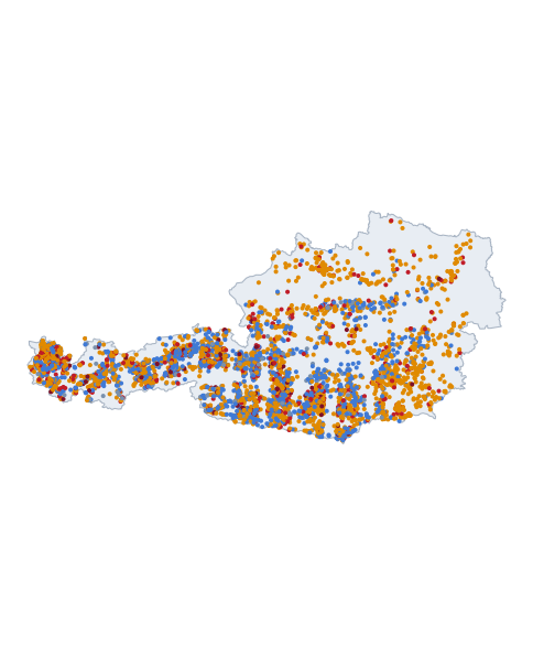 All the measured roads on one map →
Surface: · Caveated rows: (ranks stay the true ranks) · paved is preselected and the toggle drives every ranking table below; gravel, mixed and surface-unverified roads appear under all surfaces. Ranked by one steepest window, a row may be a brief sharp pitch or a sustained traditional climb — the Length and Overall columns tell you which.
On this page: steepest 10 m · 25 m · 50 m · 100 m · largest net rise · provisional (77) · all climbs (4381) · under review (2905) · toll & park roads — the rankings are the evidence-quality A/B subset; all climbs is every page, review-status and annex entries included.
Steepest 10 m
| # | Climb | Land | Max | Length | Overall | Surface | Evidence |
|---|---|---|---|---|---|---|---|
| 1 | Zaunsteinweg | Steiermark | ≈caveated35% | 968 m | 7.4% | Paved | Good |
| 2 | Rädermacher | Vorarlberg | ≈caveated34% | 1192 m | 16.9% | Paved | Good |
| 3 | Ebnit | Vorarlberg | 31% | 850 m | 12.8% | Paved | Good |
| 4 | Riegelweg | Steiermark | 30% | 551 m | 14.9% | Paved | Good |
| 5 | Fichtenweg | Salzburg | ≈caveated29% | 403 m | 15.2% | Paved | Good |
| 6 | Kehlegg | Vorarlberg | ≈caveated29% | 2932 m | 10.4% | Paved | Good |
| 7 | Talweg | Steiermark | 29% | 261 m | 16.0% | Paved | High |
| 8 | Gregerbauerweg | Steiermark | ≈caveated28% | 1072 m | 12.7% | Paved | Good |
| 9 | Fronleiten | Niederösterreich | ≈caveated28% | 770 m | 8.7% | Paved | Good |
| 10 | Hummelstraße | Steiermark | ≈caveated27% | 378 m | 11.0% | Paved | Good |
| 11 | Sonnleitenstraße | Steiermark | ≈caveated27% | 2005 m | 11.5% | Paved | Good |
| 12 | Berg | Vorarlberg | 27% | 629 m | 18.1% | Paved | Good |
| 13 | Lus | Tirol | 27% | 358 m | 17.2% | Paved | Good |
| 14 | Silberbergweg | Steiermark | ≈caveated26% | 1708 m | 12.1% | Paved | Good |
| 15 | Lane near Kuchlmühle | Oberösterreich | ≈caveated26% | 752 m | 13.7% | Paved | Good |
Steepest 25 m
| # | Climb | Land | Max | Length | Overall | Surface | Evidence |
|---|---|---|---|---|---|---|---|
| 1 | Zaunsteinweg | Steiermark | ≈caveated31.1% | 968 m | 7.4% | Paved | Good |
| 2 | Rädermacher | Vorarlberg | ≈caveated31.1% | 1192 m | 16.9% | Paved | Good |
| 3 | Kehlegg | Vorarlberg | ≈caveated27.4% | 2932 m | 10.4% | Paved | Good |
| 4 | Riegelweg | Steiermark | ≈caveated26.6% | 551 m | 14.9% | Paved | Good |
| 5 | Ebnit | Vorarlberg | 26.5% | 850 m | 12.8% | Paved | Good |
| 6 | Berg | Vorarlberg | ≈caveated26.1% | 629 m | 18.1% | Paved | Good |
| 7 | Lus | Tirol | 25.5% | 358 m | 17.2% | Paved | Good |
| 8 | Talweg | Steiermark | 25.1% | 261 m | 16.0% | Paved | High |
| 9 | Am Nordhang | Oberösterreich | 25.0% | 530 m | 14.6% | Paved | High |
| 10 | Mühldörflweg | Steiermark | 24.9% | 279 m | 16.0% | Paved | High |
| 11 | Schmirn-Leite | Tirol | 24.9% | 417 m | 11.1% | Paved | High |
| 12 | Hummelstraße | Steiermark | ≈caveated24.8% | 378 m | 11.0% | Paved | Good |
| 13 | Maier-Suppanweg | Steiermark | ≈caveated24.6% | 356 m | 13.0% | Paved | Good |
| 14 | Fichtenweg | Salzburg | ≈caveated24.2% | 403 m | 15.2% | Paved | Good |
| 15 | Buchboden | Vorarlberg | 24.1% | 715 m | 12.5% | Paved | Good |
Steepest 50 m
| # | Climb | Land | Max | Length | Overall | Surface | Evidence |
|---|---|---|---|---|---|---|---|
| 1 | Rädermacher | Vorarlberg | ≈caveated30.2% | 1192 m | 16.9% | Paved | Good |
| 2 | Kehlegg | Vorarlberg | 25.9% | 2932 m | 10.4% | Paved | Good |
| 3 | Berg | Vorarlberg | ≈caveated25.5% | 629 m | 18.1% | Paved | Good |
| 4 | Lus | Tirol | 24.4% | 358 m | 17.2% | Paved | Good |
| 5 | Am Nordhang | Oberösterreich | 24.3% | 530 m | 14.6% | Paved | High |
| 6 | Talweg | Steiermark | 24.2% | 261 m | 16.0% | Paved | High |
| 7 | Zaunsteinweg | Steiermark | ≈caveated24.1% | 968 m | 7.4% | Paved | Good |
| 8 | Mühldörflweg | Steiermark | 24.0% | 279 m | 16.0% | Paved | High |
| 9 | Riegelweg | Steiermark | ≈caveated23.7% | 551 m | 14.9% | Paved | Good |
| 10 | Maier-Suppanweg | Steiermark | ≈caveated23.6% | 356 m | 13.0% | Paved | Good |
| 11 | Astergasse | Tirol | ≈caveated23.6% | 2650 m | 13.9% | Paved | Good |
| 12 | Am Tiefen Weg | Oberösterreich | 23.3% | 357 m | 14.7% | Paved | Good |
| 13 | Tanafreida Maisäß | Vorarlberg | 23.1% | 5623 m | 13.0% | Paved | Good |
| 14 | Schmirn-Leite | Tirol | 22.8% | 417 m | 11.1% | Paved | High |
| 15 | Buchboden | Vorarlberg | 22.7% | 715 m | 12.5% | Paved | Good |
Steepest 100 m
| # | Climb | Land | Max | Length | Overall | Surface | Evidence |
|---|---|---|---|---|---|---|---|
| 1 | Rädermacher | Vorarlberg | ≈caveated29.6% | 1192 m | 16.9% | Paved | Good |
| 2 | Berg | Vorarlberg | ≈caveated24.2% | 629 m | 18.1% | Paved | Good |
| 3 | Kehlegg | Vorarlberg | 23.5% | 2932 m | 10.4% | Paved | Good |
| 4 | Astergasse | Tirol | ≈caveated22.7% | 2650 m | 13.9% | Paved | Good |
| 5 | Am Nordhang | Oberösterreich | 22.3% | 530 m | 14.6% | Paved | High |
| 6 | Mühldörflweg | Steiermark | 22.2% | 279 m | 16.0% | Paved | High |
| 7 | Talweg | Steiermark | 22.1% | 261 m | 16.0% | Paved | High |
| 8 | Tanafreida Maisäß | Vorarlberg | 22.1% | 5623 m | 13.0% | Paved | Good |
| 9 | Lane near Grodnau | Burgenland | 22.1% | 568 m | 12.7% | Paved | High |
| 10 | Lus | Tirol | ≈caveated22.0% | 358 m | 17.2% | Paved | Good |
| 11 | Zirmweg | Tirol | 21.8% | 435 m | 14.1% | Paved | High |
| 12 | Kammerjoch | Niederösterreich | ≈caveated21.3% | 595 m | 13.0% | Paved | Good |
| 13 | Maier-Suppanweg | Steiermark | ≈caveated21.2% | 356 m | 13.0% | Paved | Good |
| 14 | Fluh | Vorarlberg | ≈caveated21.2% | 226 m | 18.7% | Paved | Good |
| 15 | Am Tiefen Weg | Oberösterreich | ≈caveated21.2% | 357 m | 14.7% | Paved | Good |
≈ measured under tree canopy or near a structure at that window — the value stands but is less certain — the flag does not say whether the true value is higher or lower. Rankings include evidence quality A and B only; every row carries its surface chip, and restricted-access roads (toll/park) carry a controlled-access note — a real road lists, with its restriction stated.
Largest net rise
| # | Climb | Land | Net rise | Total ascent | Length | Overall | Surface |
|---|---|---|---|---|---|---|---|
| 1 | Tanafreida Maisäß | Vorarlberg | 730 m | 743 m | 5623 m | 13.0% | Paved |
| 2 | Türtsch | Vorarlberg | 407 m | 410 m | 3908 m | 10.4% | Paved |
| 3 | Astergasse | Tirol | 367 m | 374 m | 2650 m | 13.9% | Paved |
| 4 | Lane near Ratzell | Tirol | 338 m | 357 m | 2836 m | 11.9% | Paved |
| 5 | Arnbach | Tirol | 334 m | 335 m | 3254 m | 10.3% | Paved |
| 6 | Ellmau | Salzburg | 305 m | 305 m | 2831 m | 10.8% | Paved |
| 7 | Kehlegg | Vorarlberg | 304 m | 304 m | 2932 m | 10.4% | Paved |
| 8 | Lane near 46.71, 12.68 | Tirol | 297 m | 297 m | 2403 m | 12.4% | Paved |
| 9 | Laz | Vorarlberg | 287 m | 287 m | 2448 m | 11.7% | Paved |
| 10 | Buchenstraße | Vorarlberg | 287 m | 291 m | 2238 m | 12.8% | Paved |
| 11 | Stein...Tax | Salzburg | 284 m | 285 m | 2344 m | 12.1% | Paved |
| 12 | St. Michaeler-Bergweg | Salzburg | 284 m | 293 m | 2700 m | 10.5% | Paved |
| 13 | Lane near Freitz | Tirol | 278 m | 280 m | 2528 m | 11.0% | Paved |
| 14 | Kasbachstraße | Salzburg | 267 m | 300 m | 2205 m | 12.1% | Paved |
| 15 | Vögelsberg | Tirol | 256 m | 271 m | 2537 m | 10.1% | Paved |
Net rise is the endpoint elevation difference; total ascent counts every metre climbed, including dips regained — and, since it adds the small rises of an unsmoothed 1 m profile without ever subtracting, read it as indicative rather than surveyed (why).
Provisional measurements
Measured by exactly the same method, but the evidence quality sits below B — usually short-window maxima steep enough to trigger the plausibility review, awaiting a closer look. The numbers stand as measured; treat them as provisional until reviewed. What the evidence-quality letters mean →
| Climb | Land | Length | Overall | Max 25 m | Surface | Notes |
|---|---|---|---|---|---|---|
| Lane near Frankenberg | Kärnten | 3.5 km | 7.3% | 26.4%≈caveated | Surface unknown — likely unpaved | surface unrecorded |
| Knauderbachstraße | Kärnten | 5.2 km | 7.1% | 25.6%≈caveated | Surface unknown — likely unpaved | surface unrecorded |
| Lane near Hintereggen | Kärnten | 0.8 km | 13.5% | 25.1%≈caveated | Surface unknown — likely unpaved | surface unrecorded |
| Lane near Togain (46.7123, 14.6078) | Kärnten | 2.8 km | 11.6% | 24.8%≈caveated | Surface unknown — likely unpaved | surface unrecorded |
| Lane near Zell-Homölisch/Sele-Homeliše (46.5091, 14.4630) | Kärnten | 2.4 km | 13.9% | 24.7%≈caveated | Surface unknown — likely unpaved | surface unrecorded |
| Lane near Untergufer | Tirol | 0.4 km | 8.8% | 24.5%≈caveated | Surface unknown — likely unpaved | surface unrecorded |
| Lane near Zlattingalm | Kärnten | 6.6 km | 8.5% | 24.3%≈caveated | Surface unknown — likely unpaved | surface unrecorded |
| Seebachalpe | Kärnten | 5.9 km | 11.5% | 24.0%≈caveated | Surface unknown — likely unpaved | surface unrecorded |
| Street Gallenkirch-Gweil | Vorarlberg | 2.5 km | 13.2% | 23.9%≈caveated | Surface unknown — likely unpaved | surface unrecorded |
| Lane near Wildenstein (46.5285, 14.5043) | Kärnten | 5.2 km | 13.1% | 23.7%≈caveated | Surface unknown — likely unpaved | surface unrecorded |
| Güterweg Lobersberg | Kärnten | 11.7 km | 8.5% | 23.5% | Surface unknown — likely unpaved | surface unrecorded |
| Mellacher Bergweg | Kärnten | 6.4 km | 11.4% | 23.5%≈caveated | Surface unknown — likely unpaved | surface unrecorded |
| Fiecht | Tirol | 1.3 km | 12.3% | 22.8%≈caveated | Surface unknown — likely unpaved | surface unrecorded |
| Eigenhofen | Tirol | 0.2 km | 17.1% | 22.8%≈caveated | Paved | |
| Podlaniger Berg | Kärnten | 4.7 km | 10.0% | 22.5%≈caveated | Surface unknown — likely unpaved | surface unrecorded |
| Hof | Kärnten | 5.4 km | 9.6% | 22.2%≈caveated | Surface unknown — likely unpaved | surface unrecorded |
| Lane near Boden (46.6843, 13.5047) | Kärnten | 4.1 km | 9.9% | 22.1%≈caveated | Surface unknown — likely unpaved | surface unrecorded |
| Lane near Rauna | Kärnten | 0.9 km | 14.4% | 22.1%≈caveated | Surface unknown — likely unpaved | surface unrecorded |
| Lane near Schreigraben | Kärnten | 2.0 km | 8.4% | 22.1%≈caveated | Surface unknown — likely unpaved | surface unrecorded |
| Lane near Obere Wolayer Alpe (46.6251, 12.8495) | Kärnten | 1.5 km | 12.8% | 21.9%≈caveated | Surface unknown — likely unpaved | surface unrecorded |
| Rütisfluh | Vorarlberg | 2.1 km | 12.2% | 21.8%≈caveated | Surface unknown — likely unpaved | surface unrecorded |
| Lamm | Kärnten | 6.1 km | 6.8% | 21.6%≈caveated | Surface unknown — likely unpaved | surface unrecorded |
| Truna | Tirol | 2.7 km | 11.2% | 21.5%≈caveated | Gravel / dirt track | unpaved throughout, toll/park road — controlled access (fees, gates, seasons; see climb page) |
| Lane near Karboden | Kärnten | 6.7 km | 11.1% | 21.4%≈caveated | Surface unknown — likely unpaved | surface unrecorded |
| Forstgrabenweg | Steiermark | 1.6 km | 8.5% | 21.4%≈caveated | Surface unknown — likely unpaved | surface unrecorded |
| Laggen | Kärnten | 2.0 km | 10.9% | 21.2%≈caveated | Surface unknown — likely unpaved | surface unrecorded |
| Lane near Preisdorf | Kärnten | 0.4 km | 14.0% | 21.1%≈caveated | Surface unknown — likely unpaved | surface unrecorded |
| Zanaischg | Kärnten | 1.8 km | 11.7% | 21.0% | Surface unknown — likely unpaved | surface unrecorded |
| Lane near Stampf | Kärnten | 2.5 km | 10.5% | 20.8%≈caveated | Surface unknown — likely unpaved | surface unrecorded |
| Müllnerhalt | Oberösterreich | 0.7 km | 10.7% | 20.8%≈caveated | Surface unknown — likely unpaved | surface unrecorded |
| Lane near Rettenbach | Kärnten | 2.5 km | 12.1% | 20.6%≈caveated | Surface unknown — likely unpaved | surface unrecorded |
| Lane near Campo base per i volontari - Rossbodentörl/Passo cavallo | Kärnten | 3.8 km | 9.8% | 20.5%≈caveated | Surface unknown — likely unpaved | surface unrecorded |
| Lane near Erlachgraben (46.6643, 13.6002) | Kärnten | 3.8 km | 5.4% | 20.3%≈caveated | Surface unknown — likely unpaved | surface unrecorded |
| Lane near Ochsengarten | Kärnten | 6.7 km | 10.0% | 20.2%≈caveated | Surface unknown — likely unpaved | surface unrecorded |
| Lane near Weinberg (46.7591, 13.0995) | Kärnten | 10.8 km | 10.9% | 20.2%≈caveated | Surface unknown — likely unpaved | surface unrecorded |
| Kleinfragant | Kärnten | 4.7 km | 11.0% | 20.2%≈caveated | Surface unknown — likely unpaved | surface unrecorded |
| Lane near Rautalm | Kärnten | 3.1 km | 11.0% | 20.2%≈caveated | Surface unknown — likely unpaved | surface unrecorded |
| Lane near Jagglhütten | Kärnten | 4.1 km | 6.9% | 20.2%≈caveated | Surface unknown — likely unpaved | surface unrecorded |
| Brunntal Weg | Tirol | 4.7 km | 12.0% | 20.1%≈caveated | Surface unknown — likely unpaved | surface unrecorded, toll/park road — controlled access (fees, gates, seasons; see climb page) |
| Güterweg Thomasberg | Niederösterreich | 2.4 km | 7.5% | 20.1%≈caveated | Surface unknown — likely unpaved | surface unrecorded |
| Latischalm | Kärnten | 4.6 km | 10.9% | 20.1% | Surface unknown — likely unpaved | surface unrecorded |
| Schranzberg | Tirol | 2.1 km | 12.1% | 20.1%≈caveated | Surface unknown — likely unpaved | surface unrecorded, toll/park road — controlled access (fees, gates, seasons; see climb page) |
| Zettlweg | Steiermark | 0.7 km | 10.9% | 20.1%≈caveated | Surface unknown — likely unpaved | surface unrecorded |
| Wurzenpassstraße | Kärnten | 3.5 km | 11.9% | 19.9%≈caveated | Surface unknown — likely unpaved | surface unrecorded |
| Lane near Göriach | Kärnten | 3.9 km | 11.6% | 19.6%≈caveated | Surface unknown — likely unpaved | surface unrecorded |
| Bergstraße Farrenau | Oberösterreich | 5.1 km | 11.3% | 19.4%≈caveated | Surface unknown — likely unpaved | surface unrecorded |
| Mühlleitenstraße | Oberösterreich | 2.2 km | 12.1% | 19.3% | Surface unknown — likely unpaved | surface unrecorded |
| Winkl Ossiachberg | Kärnten | 4.6 km | 10.8% | 19.3%≈caveated | Surface unknown — likely unpaved | surface unrecorded |
| Unterhof | Kärnten | 1.6 km | 10.0% | 19.2%≈caveated | Surface unknown — likely unpaved | surface unrecorded |
| Dornbach | Kärnten | 2.5 km | 10.8% | 18.9%≈caveated | Surface unknown — likely unpaved | surface unrecorded |
…and 27 more provisional measurements — see them all in the catalogue.
What we measured, what we skipped, and why — as of November 2026
4,384 measured / 4,381 published / 1,476 ranked. Every road measured here has a record; a page is published when the open data supports it, and is held back, with a reason, when it does not yet. This is the position as of that date.
| Status | Pages | Why |
|---|---|---|
| Ranked | 1,476 | in the rankings |
| Published, not ranked | 905 | held by a review flag (track like road) |
| Published, not ranked | 862 | the road audit found an unnamed or unsurfaced service way under the route |
| Published, not ranked | 414 | the road audit found a barrier on or near the route |
| Published, not ranked | 392 | the road authority records no surface under the steepest window |
| Published, not ranked | 111 | steepest stretch on unpaved ground, where the terrain model is least reliable |
| Published, not ranked | 106 | clears none of the criteria for a ranked page |
| Published, not ranked | 26 | held by a review flag (aerial end off road) |
| Published, not ranked | 24 | the steepest window may be a driveway rather than the road |
| Published, not ranked | 22 | a record-class result that no person has yet verified |
| Published, not ranked | 14 | a steep step on a gentle road that gains little height |
| Published, not ranked | 7 | the steepest stretch is on a road the authority restricts to authorised users |
| Published, not ranked | 6 | held; reason not yet classified |
| Published, not ranked | 5 | the steepest stretch is on an access drive at the end of the line |
| Published, not ranked | 5 | the measured line or steepest window may be off the road |
| Published, not ranked | 3 | settled by a person's ruling |
| Published, not ranked | 3 | the road under the steepest window is not public |
| Withdrawn | 3 | short-crest |
| Skipped (measurement not kept) | 98 | under-200m |
| Skipped (measurement not kept) | 5 | short-crest |
Browse every climb
Real pages, not a hidden table: each link below is a page of its own with 200 climbs on it, and every one of the 4,381 published climbs appears on exactly one of them.
By Land: Burgenland 41 · Kärnten 1039 · Niederösterreich 236 · Oberösterreich 256 · Salzburg 532 · Steiermark 664 · Tirol 1123 · Vorarlberg 484 · Wien 6
Steepest first: 1 2 3 4 5 6 7 8 9 10 11 12 13 14 15 16 17 18 19 20 21 22 A–Z: 1 2 3 4 5 6 7 8 9 10 11 12 13 14 15 16 17 18 19 20 21 22
All climbs (4,381)
The complete published Austrian set — ranked rows plus the review-status and annex climbs, labelled. Click a column heading to sort; every filter mirrors into the URL so a view can be shared.
| Climb | Land | Status | Surface | Length | Net rise | Overall | Max 25 m | Evidence |
|---|
Road status under review
Measured like everything else, but these roads are absent from (or barely touched by) the GIP.at graph — usually a forest or farm track, a private drive, or a map phantom. The class sits out of the rankings until verified — each one returns as evidence clears it. Pages stay live and honest.
| Climb | Land | Length | Overall | Max 25 m | Surface | Notes |
|---|---|---|---|---|---|---|
| Discovered lane (47.2615, 10.2018) | Tirol | 0.4 km | 24.7% | 47.0% | Surface unknown — likely unpaved | surface unrecorded, not in the state road inventory — forest/camp lane or private drive likely |
| Discovered lane (46.8452, 14.1655) | Kärnten | 1.6 km | 12.6% | 45.5%≈caveated | Surface unknown — likely unpaved | surface unrecorded, not in the state road inventory — forest/camp lane or private drive likely |
| Rammernweg | Salzburg | 1.2 km | 19.8% | 44.0% | Surface unknown — likely unpaved | surface unrecorded, not in the state road inventory — forest/camp lane or private drive likely |
| Discovered lane (47.2077, 11.8514) | Tirol | 1.1 km | 14.1% | 43.3% | Surface unknown — likely unpaved | surface unrecorded, not in the state road inventory — forest/camp lane or private drive likely |
| Discovered lane (47.2087, 11.8543) | Tirol | 1.1 km | 13.7% | 43.3% | Surface unknown — likely unpaved | surface unrecorded, not in the state road inventory — forest/camp lane or private drive likely |
| Discovered lane (47.3154, 11.8107) | Tirol | 1.1 km | 17.9% | 41.7% | Surface unknown — likely unpaved | surface unrecorded, not in the state road inventory — forest/camp lane or private drive likely |
| Grübele | Tirol | 12.9 km | 7.4% | 40.7% | Surface unknown — likely unpaved | surface unrecorded, not in the state road inventory — forest/camp lane or private drive likely |
| Werfener Bürgerwaldweg | Salzburg | 3.5 km | 11.2% | 40.4%≈caveated | Surface unknown — likely unpaved | surface unrecorded, not in the state road inventory — forest/camp lane or private drive likely |
| Obertauern | Salzburg | 0.7 km | 25.0% | 39.5% | Surface unknown — likely unpaved | surface unrecorded, not in the state road inventory — forest/camp lane or private drive likely |
| Discovered lane (46.4909, 14.4879) | Kärnten | 5.6 km | 13.2% | 39.4%≈caveated | Surface unknown — likely unpaved | surface unrecorded, not in the state road inventory — forest/camp lane or private drive likely |
| Discovered lane (46.7863, 13.0853) | Kärnten | 6.9 km | 11.5% | 39.4% | Gravel / dirt track | unpaved throughout, not in the state road inventory — forest/camp lane or private drive likely |
| Discovered lane (46.4909, 14.4879) | Kärnten | 7.3 km | 10.4% | 39.0%≈caveated | Surface unknown — likely unpaved | surface unrecorded, not in the state road inventory — forest/camp lane or private drive likely |
| Gschwendboden | Tirol | 7.8 km | 10.5% | 39.0% | Surface unknown — likely unpaved | surface unrecorded, not in the state road inventory — forest/camp lane or private drive likely |
| Haidberg | Salzburg | 1.5 km | 15.7% | 38.9% | Surface unknown — likely unpaved | surface unrecorded, not in the state road inventory — forest/camp lane or private drive likely |
| Discovered lane (47.1249, 11.5045) | Tirol | 0.4 km | 27.2% | 38.5% | Gravel / dirt track | unpaved throughout, not in the state road inventory — forest/camp lane or private drive likely |
| Discovered lane (47.2213, 11.9220) | Tirol | 0.2 km | 18.0% | 38.5% | Surface unknown — likely unpaved | surface unrecorded, not in the state road inventory — forest/camp lane or private drive likely |
| Discovered lane (46.4876, 14.6446) | Kärnten | 2.5 km | 14.8% | 38.4%≈caveated | Surface unknown — likely unpaved | surface unrecorded, not in the state road inventory — forest/camp lane or private drive likely |
| 14b-Talabfahrt Bramberg | Salzburg | 3.8 km | 14.7% | 37.9%≈caveated | Surface unknown — likely unpaved | surface unrecorded, not in the state road inventory — forest/camp lane or private drive likely |
| Discovered lane (47.0151, 12.5317) | Tirol | 0.6 km | 16.1% | 37.9% | Surface unknown — likely unpaved | surface unrecorded, not in the state road inventory — forest/camp lane or private drive likely |
| Wattenberg | Tirol | 1.2 km | 11.0% | 37.8% | Surface unknown — likely unpaved | surface unrecorded, not in the state road inventory — forest/camp lane or private drive likely |
| Gleinserweg | Tirol | 3.3 km | 12.0% | 37.8% | Mixed surface | 22% unpaved, not in the state road inventory — forest/camp lane or private drive likely |
| Gstatterweg | Salzburg | 4.8 km | 12.4% | 37.8%≈caveated | Surface unknown — likely unpaved | surface unrecorded, not in the state road inventory — forest/camp lane or private drive likely |
| Discovered lane (47.3826, 11.8266) | Tirol | 1.1 km | 9.5% | 37.5% | Surface unknown — likely unpaved | surface unrecorded, not in the state road inventory — forest/camp lane or private drive likely |
| Discovered lane (47.2000, 11.8473) | Tirol | 1.8 km | 15.8% | 37.4% | Surface unknown — likely unpaved | surface unrecorded, not in the state road inventory — forest/camp lane or private drive likely |
| Hochschwendberg | Tirol | 4.7 km | 11.9% | 37.4% | Surface unknown — likely unpaved | surface unrecorded, not in the state road inventory — forest/camp lane or private drive likely |
| Glatschalm | Kärnten | 10.6 km | 10.1% | 37.3% | Surface unknown — likely unpaved | surface unrecorded, not in the state road inventory — forest/camp lane or private drive likely |
| Discovered lane (47.0373, 13.5985) | Kärnten | 3.3 km | 15.1% | 37.1%≈caveated | Surface unknown — likely unpaved | surface unrecorded, not in the state road inventory — forest/camp lane or private drive likely |
| Dorfberg | Tirol | 3.7 km | 11.0% | 37.0%≈caveated | Surface unknown — likely unpaved | surface unrecorded, not in the state road inventory — forest/camp lane or private drive likely |
| Discovered lane (47.3667, 12.1184) | Tirol | 1.6 km | 11.4% | 36.9% | Surface unknown — likely unpaved | surface unrecorded, not in the state road inventory — forest/camp lane or private drive likely |
| Discovered lane (47.1887, 11.8154) | Tirol | 2.7 km | 12.5% | 36.9%≈caveated | Surface unknown — likely unpaved | surface unrecorded, not in the state road inventory — forest/camp lane or private drive likely |
| Unterberg | Tirol | 4.8 km | 11.0% | 36.9%≈caveated | Surface unknown — likely unpaved | surface unrecorded, not in the state road inventory — forest/camp lane or private drive likely |
| Discovered lane (47.3684, 12.1226) | Tirol | 1.0 km | 13.1% | 36.9% | Gravel / dirt track | unpaved throughout, not in the state road inventory — forest/camp lane or private drive likely |
| Discovered lane (47.1220, 11.4778) | Tirol | 0.8 km | 13.6% | 36.9% | Surface unknown — likely unpaved | surface unrecorded, not in the state road inventory — forest/camp lane or private drive likely |
| Gföll | Salzburg | 2.2 km | 11.2% | 36.9% | Surface unknown — likely unpaved | surface unrecorded, not in the state road inventory — forest/camp lane or private drive likely |
| Discovered lane (47.2024, 11.8289) | Tirol | 1.4 km | 12.9% | 36.9% | Surface unknown — likely unpaved | surface unrecorded, not in the state road inventory — forest/camp lane or private drive likely |
| Discovered lane (46.8704, 13.6174) | Kärnten | 1.6 km | 20.2% | 36.8%≈caveated | Surface unknown — likely unpaved | surface unrecorded, not in the state road inventory — forest/camp lane or private drive likely |
| Discovered lane (47.1225, 11.4798) | Tirol | 1.0 km | 12.4% | 36.4% | Surface unknown — likely unpaved | surface unrecorded, not in the state road inventory — forest/camp lane or private drive likely |
| Discovered lane (46.9619, 13.6610) | Kärnten | 4.7 km | 9.3% | 36.0% | Surface unknown — likely unpaved | surface unrecorded, not in the state road inventory — forest/camp lane or private drive likely |
| Discovered lane (46.7618, 13.1122) | Kärnten | 1.9 km | 11.5% | 35.9%≈caveated | Surface unknown — likely unpaved | surface unrecorded, not in the state road inventory — forest/camp lane or private drive likely |
| Discovered lane (46.8884, 14.1150) | Kärnten | 1.2 km | 12.3% | 35.7% | Surface unknown — likely unpaved | surface unrecorded, not in the state road inventory — forest/camp lane or private drive likely |
| Baldramsdorf | Kärnten | 11.0 km | 10.5% | 35.6% | Surface unknown — likely unpaved | surface unrecorded, not in the state road inventory — forest/camp lane or private drive likely |
| Staneralm | Kärnten | 9.7 km | 11.7% | 35.3%≈caveated | Paved | not in the state road inventory — forest/camp lane or private drive likely |
| Steinbichl | Kärnten | 2.1 km | 8.8% | 35.2%≈caveated | Surface unknown — likely unpaved | surface unrecorded, not in the state road inventory — forest/camp lane or private drive likely |
| Grafenweg | Tirol | 1.4 km | 11.0% | 35.1%≈caveated | Surface unknown — likely unpaved | surface unrecorded, not in the state road inventory — forest/camp lane or private drive likely |
| Discovered lane (47.3368, 11.8322) | Tirol | 0.6 km | 19.9% | 35.0% | Surface unknown — likely unpaved | surface unrecorded, not in the state road inventory — forest/camp lane or private drive likely |
| Schlögelbergweg | Salzburg | 7.2 km | 11.4% | 35.0% | Surface unknown — likely unpaved | surface unrecorded, not in the state road inventory — forest/camp lane or private drive likely |
| Discovered lane (47.2334, 11.8603) | Tirol | 0.2 km | 24.4% | 35.0% | Surface unknown — likely unpaved | surface unrecorded, not in the state road inventory — forest/camp lane or private drive likely |
| Schönbergweg, Oberau | Tirol | 0.5 km | 14.7% | 34.9%≈caveated | Surface unknown — likely unpaved | surface unrecorded, not in the state road inventory — forest/camp lane or private drive likely |
| Discovered lane (47.2594, 11.8761) | Tirol | 0.4 km | 16.7% | 34.8%≈caveated | Surface unknown — likely unpaved | surface unrecorded, not in the state road inventory — forest/camp lane or private drive likely |
| Lane near Brantach | Tirol | 0.5 km | 20.0% | 34.8% | Surface unknown — likely unpaved | surface unrecorded, not in the state road inventory — forest/camp lane or private drive likely, the steepest stretch looks like a track rather than a made road — pending human review |
…and 2,855 more roads under review — see them all in the catalogue.
Restricted roads rank too — with their restriction stated
63 roads open to bicycles but closed to general motor traffic (forest and alp roads, toll roads) are fully measured and rank in the tables above — a real road lists, with its restriction noted rather than silently ranked away. Their rows carry a controlled-access note (fees, gates, seasons) and each page has the details.
Sources & credit
Elevation: ALS DTM 1 m © BEV and the Länder (CC BY 4.0), measured in the model’s own ETRS89 / LAEA projection (scale error under 0.2 %). Road geometry: © OpenStreetMap contributors (ODbL). Road classes, surfaces and access: GIP.at © ÖVDAT (CC BY 4.0). Place and Land names: OpenStreetMap administrative boundaries. Updated 10 November 2026 — what changed. Full terms: licensing & reuse.