Surface unknown — likely unpaved · listed, not ranked
1492.0 m · net rise 91.2 m · total ascent 119.2 m · overall 6.1% · evidence quality B (good) · Krems in Kärnten · Kärnten
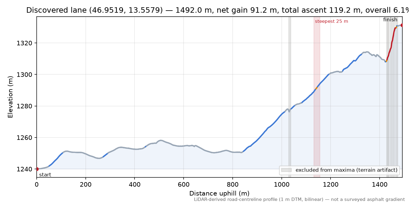
Shape: stepped — 47% of the climbing sits in a quarter of the distance; longest continuous stretch at 10%+ is 157 m.
Found purely from mapping and LiDAR data, and not yet matched against books, race records or lists — it may be well known to locals under a name we've never heard. It was cross-checked against the GIP.at road network, OpenStreetMap and a second terrain model, but a discovery can still be an artifact of the terrain model or the map. Treat it as a well-evidenced hypothesis until someone has ridden it. If you know this road, tell us what you found — photographs, corrections and local knowledge all welcome; the map links below let you scout it first.
Lane near Jagdhaus Ronnach (Krems in Kärnten, Kärnten) is 1492.0 m long at 6.1% overall; its steepest 25 m averages ≈20.4% and its steepest 100 m ≈16.6%, measured from Austria's national 1 m airborne-laser terrain model along the mapped road centreline.
Gradient ladder what do windows mean?
| Window | Maximum | Located at | |
|---|---|---|---|
| 2 m (diagnostic) | ≈51% | 1442–1444 m | under overhead cover terrain reads 112.5% at 1447–1449 m across a structure — excluded |
| 3 m (diagnostic) | ≈48% | 1441–1444 m | under overhead cover terrain reads 107.3% at 1447–1450 m across a structure — excluded |
| 5 m | ≈25% | 1247–1252 m | under overhead cover terrain reads 89.1% at 1453–1458 m across a structure — excluded |
| 10 m | ≈21% | 1130–1140 m | under overhead cover terrain reads 83.3% at 1447–1457 m across a structure — excluded |
| 20 m | ≈20.6% | 1130–1150 m | under overhead cover terrain reads 69.7% at 1442–1462 m across a structure — excluded |
| 25 m | ≈20.4% | 1131–1156 m | under overhead cover terrain reads 65.9% at 1437–1462 m across a structure — excluded |
| 50 m | ≈18.5% | 1129–1179 m | under overhead cover terrain reads 45.6% at 1424–1474 m across a structure — excluded |
| 100 m | ≈16.6% | 1092–1192 m | under overhead cover terrain reads 19.8% at 1385–1485 m across a structure — excluded |
may continue beyond end Extent detection suggests reviewing where this climb starts/ends.
Map
Check this route yourself: Google Maps route via their router · Street View at the base where coverage exists · geojson.io our exact measured line · OpenTopoMap
This climb's data: OCL JSON — the full gradient ladder, quality flags and provenance in the OpenClimb Ladder format.
Surface: GIP.at, Austria's official transport graph records no surface for this road; the map may tell you more.
Pending human review: the steepest stretch of this climb (1131–1156 m) looks like a track rather than a made road: the aerial photograph shows it is not a made public road (a private drive, a track, grass, or a line that leaves the road). The figure is published as measured and has not been adjusted, but a climb whose steepest stretch looks like a track is listed, not ranked, until a person has looked.
Measured, not vetted. This page records what the laser record shows about the road's shape — nothing more. Nobody has necessarily ridden or inspected this road for the survey, and a page here is not a recommendation and no guarantee that the road is open, surfaced, rideable or safe. Gates, private sections, missing rights of way and hazards do not show up in elevation data. Check access and conditions on the ground and make your own judgment.
Ridden it, or know better? Submit data for this climb no account needed · Share this climb
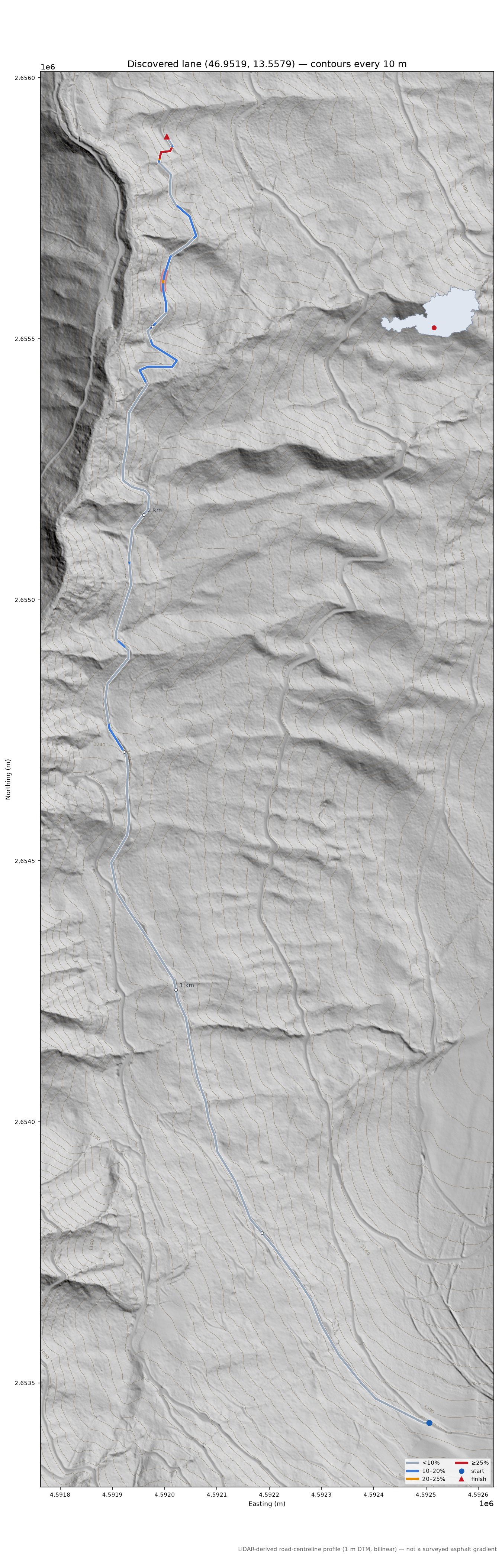
Route colour = gradient over a 25 m window: <10% 10–20% 20–25% ≥25%
Route line = the road surface as the LiDAR survey finds it. Basemap roads are for orientation and may sit a few metres off.
© OpenStreetMap contributors · topo tiles © OpenTopoMap (CC-BY-SA) · vector tiles OpenFreeMap · aerial imagery © basemap.at (CC BY 4.0)
Profile
The map, profile and gradient chart share one position — move your pointer over them and the marker follows. Colors are the gradient bands; the shaded span is the steepest 25 m. Any 25 m figure is good to about a point either way (why).

Measurement card
| Elevation | BEV ALS DTM 1 m — ALS DTM Höhenraster 1 m (Bundesamt für Eich- und Vermessungswesen with the Länder), EPSG:3035 |
|---|---|
| Resolution / CRS | 1.0 m grid, EPSG:3035; sampled every 1.0 m, bilinear interpolation |
| Tiles | E4591-N2653, E4591-N2654, E4591-N2655, E4592-N2653, E4592-N2654, E4592-N2655 |
| Road centreline | OpenStreetMap (local PBF extract) |
| Quality status | evidence quality B; caveated windows: structure excluded, suppression carried, texture excluded, texture excluded min |
| Analysis | OCL 0.1.0, analysis 0.1.0, run remeasure-valley-260921-at, calculated 2026-09-22 |
Provenance
{
  "analysis_version": "0.1.0",
  "run_manifest": {
    "manifest_version": "1",
    "code_git_sha": "8f4becd2ed8ab26772f5cd961ca7d1d0c2823252",
    "code_git_dirty": "false",
    "analysis_version": "0.1.0",
    "analysis_config_digest": "sha256:8c94015b54267da4",
    "python": "3.14.4",
    "numpy": "2.5.3",
    "rasterio": "1.5.1",
    "pyproj": "3.8.0",
    "laspy": "2.7.0",
    "shapely": "2.1.2",
    "pyosmium": "4.3.1",
    "libosmium": "2.23.1",
    "gdal": "3.12.4",
    "proj": "9.8.1",
    "run_id": "remeasure-valley-260921-at",
    "road_pbf": "batch-austria-chunk000.pbf",
    "region_key": "austria",
    "crs": "EPSG:3035",
    "elevation_provider_key": "bev-als",
    "tile_index": "cog-grid",
    "authority": "gip",
    "registry_pbf": "austria-2026-09-11.osm.pbf",
    "tile_index_snapshot": "sha256:b8dc649d37698355"
  },
  "sample_interval_m": 1.0,
  "interpolation": "bilinear",
  "smoothing": "none",
  "gradient_windows_m": [
    5.0,
    10.0,
    20.0,
    25.0,
    50.0,
    100.0
  ],
  "diagnostic_windows_m": [
    2.0,
    3.0
  ],
  "elevation_crs": "EPSG:3035",
  "elevation_resolution_m": 1.0,
  "elevation_tiles": [
    "data/cache/at/bev-als_dtm_E4591-N2653@20220915.tif",
    "data/cache/at/bev-als_dtm_E4591-N2654@20220915.tif",
    "data/cache/at/bev-als_dtm_E4591-N2655@20220915.tif",
    "data/cache/at/bev-als_dtm_E4592-N2653@20220915.tif",
    "data/cache/at/bev-als_dtm_E4592-N2654@20220915.tif",
    "data/cache/at/bev-als_dtm_E4592-N2655@20220915.tif"
  ],
  "calculated_at": "2026-09-22T00:04:46+00:00",
  "road_source": "OpenStreetMap (local PBF extract)",
  "road_attribution": "\u00a9 OpenStreetMap contributors, ODbL",
  "osm_pbf_path": "output/valley-260921/at/batch-austria-chunk000.pbf",
  "osm_snapshot": "",
  "run_id": "remeasure-valley-260921-at",
  "elevation_provider": "BEV ALS DTM 1 m",
  "elevation_licence": "Creative Commons Attribution 4.0 (CC BY 4.0) \u2014 \u00a9 BEV / L\u00e4nder, data.gv.at",
  "elevation_dataset": "ALS DTM H\u00f6henraster 1 m (Bundesamt f\u00fcr Eich- und Vermessungswesen with the L\u00e4nder), EPSG:3035",
  "elevation_tile_ids": [
    "E4591-N2653",
    "E4591-N2654",
    "E4591-N2655",
    "E4592-N2653",
    "E4592-N2654",
    "E4592-N2655"
  ],
  "elevation_blocks": [
    "N2650000E4550000@2022-09-15"
  ],
  "bev_dsm_release": {
    "N2650000E4550000": "20220915"
  },
  "route_base_cut_m": 1455.0,
  "climb_origin": "discovered",
  "structure_own_ways": "none \u2014 the route carried no way list and no mapped way runs along it; own decks unmasked",
  "prior_doc": {
    "slug": "discovered-lane-46-9519-13-5579",
    "calculated_at": "2026-09-13T00:58:33+00:00",
    "code_git_sha": null,
    "analysis_version": "0.1.0",
    "run_id": "at-run4-260912",
    "path": "output/valley-260921/at/priors/discovered-lane-46-9519-13-5579/discovered-lane-46-9519-13-5579.json",
    "spans": 6,
    "sources": [
      "excluded_ranges_m",
      "texture"
    ]
  },
  "suppression_carried": [
    {
      "window_m": 5.0,
      "start_m": 1467.0,
      "end_m": 1472.0,
      "raw_pct": 25.55,
      "reason": "mask-edge",
      "published_reason": "masked",
      "published_span_m": [
        2920.0,
        2949.0
      ],
      "published_pct": 24.268414901639517,
      "perturbation_hits": 1,
      "perturbations": 3,
      "gap_m": 0.0
    }
  ],
  "carriageway": {
    "stations": 66,
    "stations_resolved": 66,
    "width_median_m": 3.5,
    "width_p10_m": 2.5,
    "width_min_m": 1.25,
    "width_max_m": 11.0,
    "bounded_share": 0.455,
    "unbounded_share": 0.545,
    "confidence_median": 0.0,
    "width_median_bounded_m": 3.25,
    "window_m": [
      1131.0,
      1156.0
    ],
    "width_at_max25_m": 3.0,
    "window_stations": 7,
    "single_track": false,
    "single_track_rule": "PROVISIONAL (2026-09-15): width_p10_m <= 3.0 m with bounded_share >= 0.6; recorded, not a rule",
    "status": "ok",
    "source": "dtm",
    "station_m": 25.0,
    "window_station_m": 5.0,
    "halfwidth_m": 6.0,
    "step_m": 0.25,
    "level_tol_m": 0.12,
    "break_min_m": 0.3,
    "stations_failed": 0,
    "hedge_to_hedge": {
      "stations": 66,
      "stations_resolved": 66,
      "width_median_m": 6.62,
      "width_p10_m": 4.38,
      "width_min_m": 1.75,
      "width_max_m": 12.0,
      "bounded_share": 0.864,
      "unbounded_share": 0.136,
      "confidence_median": 1.0,
      "width_median_bounded_m": 6.25,
      "window_m": [
        1131.0,
        1156.0
      ],
      "width_at_max25_m": 6.25,
      "window_stations": 7,
      "status": "ok",
      "source": "dsm",
      "station_m": 25.0,
      "window_station_m": 5.0,
      "halfwidth_m": 6.0,
      "step_m": 0.25,
      "level_tol_m": 0.5,
      "break_min_m": 0.3,
      "stations_failed": 0
    }
  },
  "remeasured": {
    "on": "2026-09-22",
    "why": "valley-crossing extent re-measure 2026-09-22: low-to-summit (1455.0 m -> 2949.0 m)",
    "published_max25_pct": 20.42,
    "max25_pct": 20.41
  },
  "license": "ODbL-1.0",
  "license_url": "https://howsteep.org/licensing"
}