← survey home · UK climbs · US climbs · Swiss climbs · Austrian climbs · French climbs · NZ climbs · Norwegian climbs
Every climb on one map
All 26,222 published climbs — the UK, the US, Switzerland, Austria, France, New Zealand and Norway on one map (6,754 in this country) — coloured by their steepest 25 m. Click a dot for the climb’s page; the buttons below re-frame the map on another country. Coverage follows the open LiDAR record — an empty region usually means missing data, not missing hills.
Browse all 6754 US climbs — the full rankings →
· · region: · frame: © OpenStreetMap contributors · topo tiles © OpenTopoMap (CC-BY-SA) · vector tiles OpenFreeMap
The interactive map could not load (the map library or the basemap tiles are unreachable). The survey’s own picture of the same climbs:
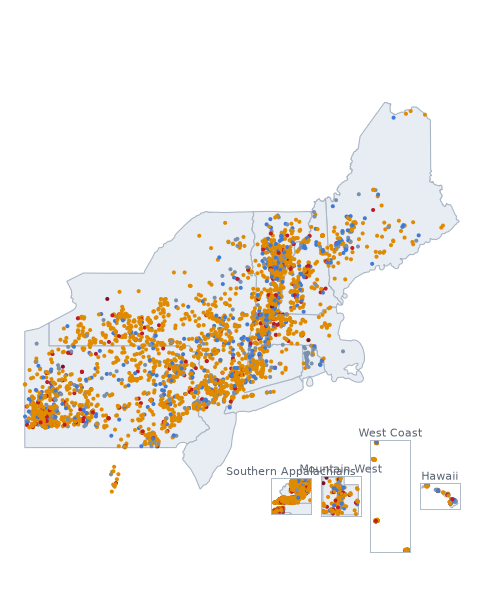
Coverage footprint — the six New England states, New York, screened end to end against USGS 3DEP 1 m LiDAR and each state’s road inventory; New Jersey only where its 1 m projects exist — 1 m LiDAR covers the north-west six counties (2017), South Jersey (2018), the north-east counties (post-Sandy 2014 lot) and the Delaware Valley counties (2015); the map shades the footprint the survey holds — the north-east and Delaware Valley blocks were registered on 2026-09-06 and their roads join in the next wave.; Pennsylvania only where its 1 m projects exist — 1 m LiDAR from ten USGS 3DEP projects (2014-2020) covers most of the state; the map shades the footprint the survey holds.; Hawaii only where its 1 m projects exist — 1 m LiDAR from three USGS 3DEP projects (2017-2020) covers Kauai, Oahu, Molokai, Lanai, Maui and the Big Island; the map shades the footprint the survey holds.; California only where its 1 m projects exist — Only the surveyed San Francisco + East Bay hill district is covered (Filbert/Hyde-Leavenworth, 22nd St Vicksburg-Church, the Berkeley/Oakland hills) — this is a city run, not a California state survey; the map shades the bbox the survey holds. Only the surveyed Los Angeles hill district is covered (Eldred St, Baxter St, Fargo St and the Silver Lake/Echo Park/Mt Washington/Hollywood Hills/Palisades area) — a city run, not statewide; the map shades the bbox the survey holds.; Washington only where its 1 m projects exist — Only the surveyed Seattle hill district is covered (Queen Anne, Capitol Hill/E Roy St) — a city run, not statewide; the map shades the bbox the survey holds.; Oregon only where its 1 m projects exist — Only the surveyed Portland hill district is covered (West Hills incl. Council Crest/Fairmount, SW, Mt Tabor, Rocky Butte) — a city run, not statewide; the map shades the bbox the survey holds.; Utah only where its 1 m projects exist — 1 m LiDAR from 44 USGS 3DEP projects (2014-2024) covers most of the state; the map shades the footprint the survey holds.; North Carolina only where its 1 m projects exist — Western North Carolina is covered from the Great Smoky Mountains crest east to Asheville and the Blue Ridge (Haywood, Jackson, Swain, Buncombe, Henderson and Madison counties) - a regional run, not statewide; the map shades the footprint the survey holds.; West Virginia only where its 1 m projects exist — Central and eastern West Virginia is covered, the Allegheny Front and the Monongahela highlands (Spruce Knob, Dolly Sods, Canaan, Snowshoe, the Highland Scenic Highway, Seneca Rocks) west to Morgantown and Summersville - a regional run on three 10 km lidar cells, not statewide; the map shades the footprint the survey holds.; Virginia only where its 1 m projects exist — The mountain west of Virginia is covered - the Blue Ridge and Shenandoah (Skyline Drive, the Blue Ridge Parkway, Massanutten, Reddish Knob), the Alleghany Highlands and Mount Rogers / southwest Virginia - a regional run west of 78 degrees W on 1 m lidar, not statewide: the Piedmont, Southside and Tidewater are not covered, and the map shades the footprint the survey holds. (New York appears only where a border road starts there). Unshaded ground is where no open 1 m LiDAR was in the record when the survey ran: not “no hills”, not yet measurable. The footprint is computed from the survey’s own tile archive, never asserted.
Filled dots are climb pages. Dot colour: ● <15% ● 15–20% ● 20–25% ● 25–30% ● 30%+ — steepest 25 m window, the same figure the tables rank by. Marker style shows the surface: a solid dot is a paved road; a ring (hollow centre) is a gravel, dirt or mixed road or one estimated unpaved; a faint dot with a dark edge is a road whose surface is unknown, likely unpaved. A grey-blue or blue dot is a page that earned its place another way (a long climb, a big total ascent, a listed or founding climb) — the same rule in every country.