Henllys to Nant Carn°
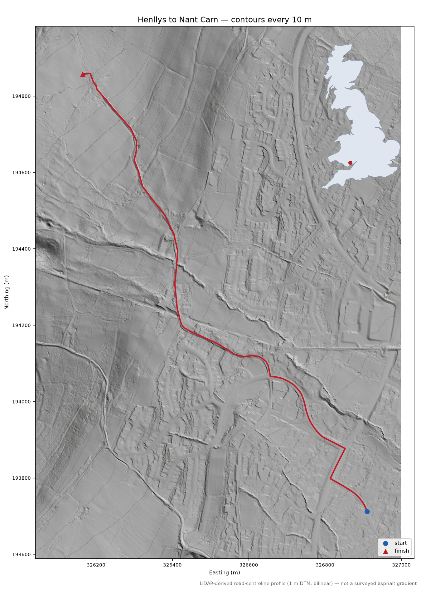
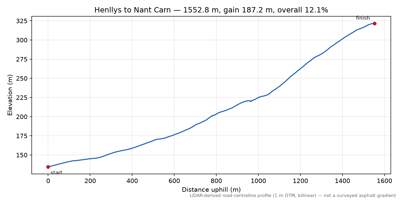
1552.8 m · gain 187.2 m · overall 12.1% · Henllys · Torfaen
Shape: sustained — 41% of the climbing sits in a quarter of the distance; longest continuous stretch at 10%+ is 444 m.
An unlisted find of this survey, on no list we know of. It was discovered by analysing LiDAR terrain data and cross-checked against the OS road network, surface models and map tags — but despite all that, a discovery can still be an artifact of the terrain model or the map. Treat it as a well-evidenced hypothesis until someone has ridden it. If that someone is you, tell us what you found — photographs, corrections and local knowledge all welcome; the map links below let you scout it first.
° The name is provisional: this climb appears on no list we know of, so it was named from nearby map places. There is no evidence of local usage — (auto-named from gazetteer (hypothesis, unreviewed); discovered as 'Discovered lane (51.6412, -3.0630)'). Corrections welcome.
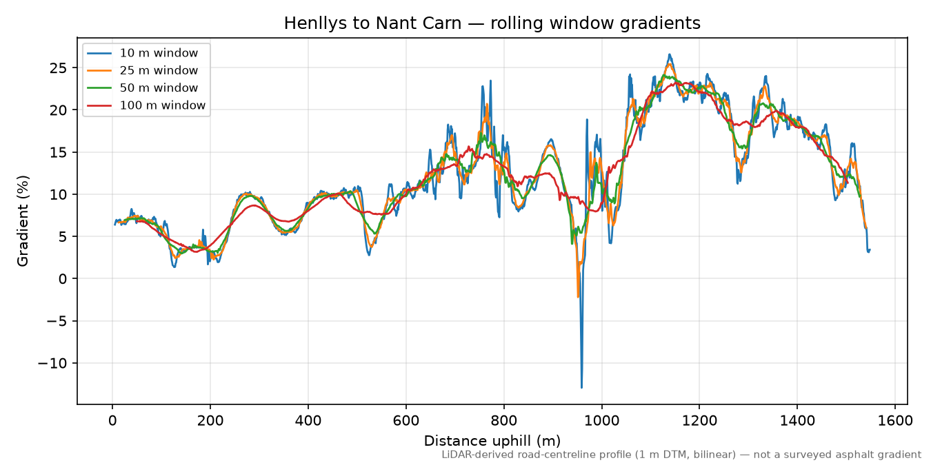
≈ Overhead cover (tree canopy or structures) spans 36% of this route — detected by comparing the surface model (DSM, treetops and rooftops) against the terrain model (DTM, bare ground). Under cover the bare-ground model is built from fewer laser returns, so metre-scale readings can wobble; maxima whose window sits in a covered zone are marked ≈ below — less certain, not wrong. Longer windows average over more clean ground and are steadier.
Gradient ladder what do windows mean?
| Window | Maximum | Located at | |
|---|---|---|---|
| 2 m (diagnostic) | 53.9% | 965–967 m | |
| 3 m (diagnostic) | 41.0% | 964–967 m | |
| 5 m | ≈29.7% | 756–761 m | under overhead cover |
| 10 m | ≈26.6% | 1134–1144 m | under overhead cover |
| 20 m | ≈25.7% | 1133–1153 m | under overhead cover |
| 25 m | ≈25.4% | 1128–1153 m | under overhead cover |
| 50 m | ≈24.1% | 1101–1151 m | under overhead cover |
| 100 m | ≈23.2% | 1101–1201 m | under overhead cover |
may_start_earliermay_continue_beyond_end Extent detection suggests reviewing where this climb starts/ends.
Map
Check this route yourself: Google Maps route via their router · Street View at the base where coverage exists · geojson.io our exact measured line · OpenTopoMap
© OpenStreetMap contributors · topo tiles © OpenTopoMap (CC-BY-SA) · vector tiles OpenFreeMap
Profile
Provenance
{
  "analysis_version": "0.1.0",
  "sample_interval_m": 1.0,
  "interpolation": "bilinear",
  "smoothing": "none",
  "gradient_windows_m": [
    5.0,
    10.0,
    20.0,
    25.0,
    50.0,
    100.0
  ],
  "diagnostic_windows_m": [
    2.0,
    3.0
  ],
  "elevation_crs": "EPSG:27700",
  "elevation_resolution_m": 1.0,
  "elevation_tiles": [
    "data/cache/wales/dtm_1m/wg_del_5_326193_20201224dtm.tif",
    "data/cache/wales/dtm_1m/wg_del_5_326194_20201224dtm.tif"
  ],
  "calculated_at": "2026-08-12T09:06:43+00:00",
  "road_source": "OpenStreetMap (local PBF extract)",
  "road_attribution": "\u00a9 OpenStreetMap contributors, ODbL",
  "osm_pbf_path": "data/cache/pbf/wales-2026-08-11.osm.pbf",
  "osm_snapshot": "2026-08-10T20:21:40Z",
  "elevation_provider": "Welsh Government",
  "elevation_dataset": "Welsh Government LiDAR 1m DTM (2020-2023)",
  "elevation_licence": "Open Government Licence v3 \u2014 \u00a9 Crown copyright Welsh Government",
  "elevation_catalogue_layer": "geonode:welsh_government_lidar_tile_catalogue_2020_2023",
  "elevation_tile_ids": [
    "wg_del_5_326193_20201224dtm.tif",
    "wg_del_5_326194_20201224dtm.tif"
  ],
  "elevation_capture_dates": [
    "24-12-2020"
  ],
  "climb_origin": "discovered",
  "notes": "Coarse pass: max 13.6% over 200 m (Terrain 50), gain 47.4 m over 397 m way. EXTENDED by graph walk: +9 segment(s) at base, +2 at top (stop: base=no_descending_continuation, top=no_ascending_continuation; min_avg=2.0%). Review before adopting. DEDUPE: absorbed 4 overlapping proposal(s): discovered-lane-51-6456-3-0665, dorallt-close, dorallt-way, greenwood-drive ROAD-REVIEW: way 94958021: unnamed service way; way 94958021: service way, surface untagged ADOPTED (notable slice 2026-08-11): endurance. AUTO-NAMED from gazetteer (hypothesis, unreviewed): was 'Discovered lane (51.6412, -3.0630)'.",
  "naming_note": "auto-named from gazetteer (hypothesis, unreviewed); discovered as 'Discovered lane (51.6412, -3.0630)'"
}